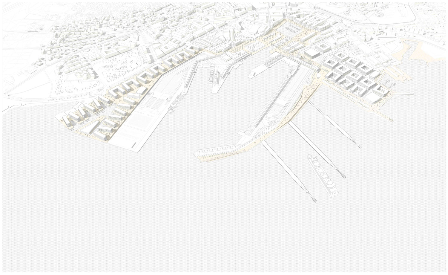
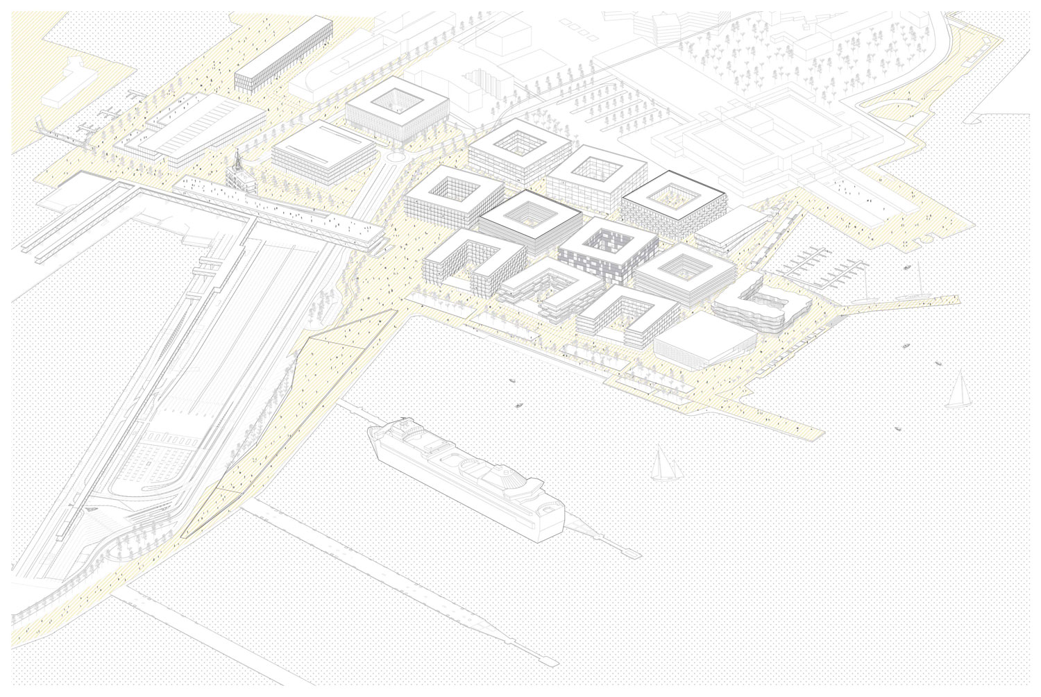
☉ Tallinn Sadama Masterplan is a finalist proposal by AZPML for Port of Tallinn designed in 2017. It is located in Tallinn Estonia in a seaside setting. Its scale is extralarge with a surface of 540.000 sqm. Concepts such as new development u shape and connection are explored.


The object of this competition, the re-establishment of the relationship between Tallinn and its Port, is crucial for the future of Tallinn as an emerging Northern European city. Without exaggerating, we believe that the restructuring of the relationship between Tallinn and its Port is the single most important opportunity that Tallinn will have in the next century, and its success will have an enormous impact on the future of the city, not only as a reserve of urban land for the growth of the city, but also as a key element of the identity of Tallinn.
A global question
The Tallinn case is not unique. There is a well known casuistic of port cities which have followed and are still follow¬ing similar processes of reconversion. Like many other cities such as London, Hamburg, Copenhagen, Oslo, Barcelona or Genova, Tallinn’s very history starts with the Port, as an enclave inevitably related to the sea, commercially and spiritually. The 19th and 20th Century bear witness to a complete separation between the urban domain and the port domain, and often a conflictive relationship between them. Once the Port operations became more complex and sophisticated, burdened with technology, security and trade issues, ports became increasingly detached from the cities that created them: very often, the authority over the port land became different to the authority over the city, and fences appeared to separate neatly both domains.
It was only at the end of the 20th Century that some port cities started to overtake their ports, as modern port operations began to require increasingly large facilities for increasingly large vessels, and real estate surpluses became a stronger reve¬nue than the traditional port operation. Many cities, world-wide, shifted the port operations away from the city center, and recycled the former harbors into urban fabrics. The redevelopment of Boston and Baltimore, the London Docklands, the Rotterdam Harbor, the Hamburg and Copenhaguen Dockyards, Singapore’s Harbor, Shanghai or Hong-Kong, Puerto Madero in Buenos Aires… the general tendency was to entirely remove the Port uses and redevelop the former industrial land into waterfront developments which benefit from the views to the water.
While many of these developments have been phenomenally successful and provided these cities with substantial amounts of high-quality urban land which have often yielded some of the highest rents in the local real estate markets, they have often failed to retain the quality of the harbor activities which form the crux of the urban identity of port cities. In many of these operations, the higher rents of the waterfront developments have also produced a cultural segregation between the more affluent sectors of the population and the tourists, and the population with more modest income.
A local solution
In Tallinn, we would like to avoid this erasure of the identity of the city as a port city, and to use the Port development as a tool for social cohesion and integration through cultural activities and public spaces. In many ways the relatively small scale of the Tallinn Port, and its passenger/tourist-driven focus make the integration between the port and the city easier than in the examples we have mentioned, often driven by more industrial/cargo activities. On the other hand, the cruise operation in Tallinn is phenomenally successful and very large by comparison with the scale of the cities. The port of Tallinnis one of the busiest cruise and passenger harbors inNorthern Europewith over 10 million people passing through in 2016.
The scale needed for the roll-on roll-off and logistic platforms is substantial, and the logistic problems of bringing so many vehicles to the harbor through the city centre represents a substantial challenge in the redefinition between the port and the city of Tallinn, and will require imaginative solutions to reorganize this traffic. There are now just-in-time technologies, enabled by GPS and online applications which will enable the displacement of the more aggressive part of this traffic, without erasing the presence of the port in the urban core.Nevertheless, we firmly believe that these type of disturbance can be resolved effectively without being forced to move these operations outside the urban core. In any case, perhaps our most important target with this project is to make these two activities compatible, rather than simply turning the port land into urban land by removing port activities from the old port. We believe that Tallinn’s identity is inextricably linked to the harbor, and this is a trait that we would very much like to preserve as a key quality of the fu¬ture city growth: not only the cruise industry contributes substantially to the economy of Tallinn, but we believe that the presence of the harbor, however noisy and sometimes obnoxious, is an integral part of Tallinn’s identity with very specific traits.
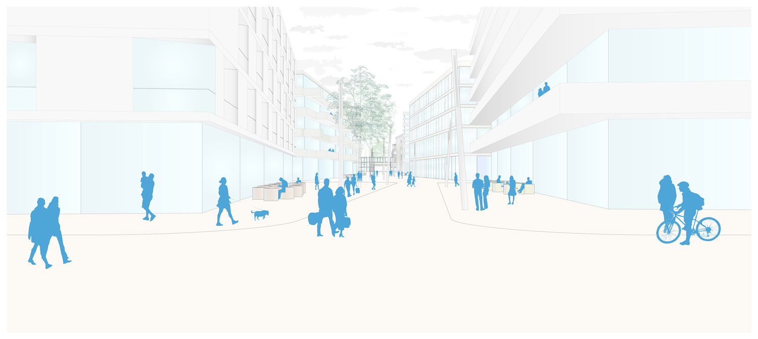
This is the reason why we have avoided to address the reengagement between Tallinn and its port in a spectacular fashion, like many of this type of developments have done in the past. No fancy -and expensive- Opera Houses and Musea. We have rather concentrated in the study of the existing urban fabric and activities in the area trying to re¬spond in a very specific and modest key, ensuring that the proposals that we are making will not entirely fall onto the pockets of the city -and its taxpayers- while providing new areas of expansion where the city can grow with a mul¬ti-functional tissue, dimensioned to accommodate efficiently residential, commercial and retail and leisure functions indistinctively, while taking good care to dimension the new public spaces and streets to optimize the micro-climate and the social and logistic performance of these new public spaces. The purpose of our masterplan is to channel the private initiative to generate a sophisticated and accessible public space system for the future of Tallinn, instead of compromising the taxpayer’s money into the construction of expen¬sive and spectacular infrastructure. Our masterplan proposal aims to do this while preserving the specific identity of Tallinn as a unique port city, maintaining the harbor as an important source of revenue for the local economy.
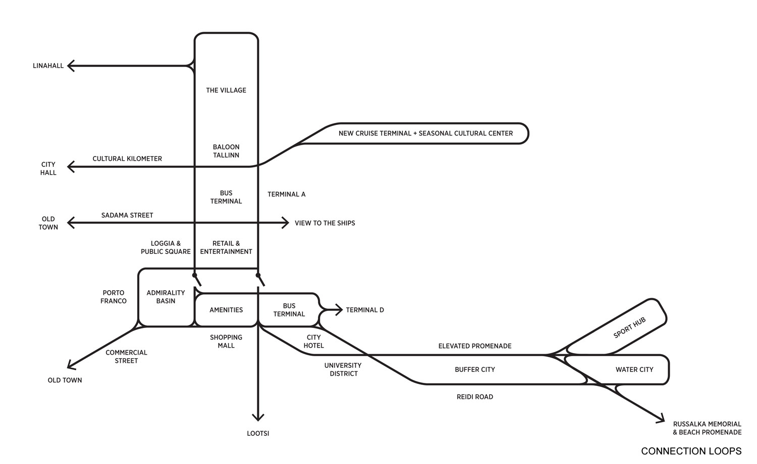
A network of perpendicular programmatic threads
Beyond the development of a consistent waterfront promenade, we have developed a number of perpendicular structures aimed to thread the urban fabric to the port domain. These transversal axis are primarily built on some dis¬tinctive existing urban activities. These programmatic axes could help to connect port area to existing core of the city through programmatic consistency, much like the old medieval town had structures in areas specialized on a certain trade, jewelers, carpenters, food…
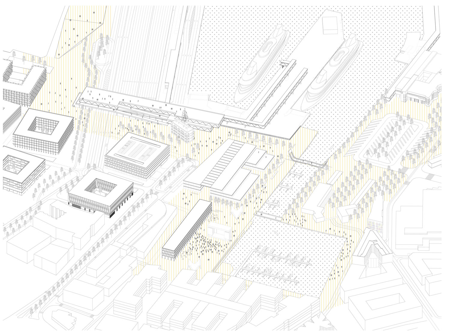
Redevelopment of Sadama street and Bastion belt. Sadama street is the extension of first medieval pier (pre 17th c). After turning bastions into a continuous park around the old town in1860, the continuity between the port and the old town was broken by industrialisation of the port. This break became more pronounced due to sprawling car traffic in the 20th Century. To connect the harbor and the old town, the treatment of the bastion belt will be crucial. Our proposal is to redevelop the street together with the bastion belt and open up the view to the sea at the end of the street. Kaupmehe Sild is the oldest part of todays port (dating from 18th c) and is currently a closed behind the terminals. Our proposal is to remove the current terminal to provide a view to the harbor and the ships along Sadama street. Sadama street will be treated as one branch of the bastion belt. We will complement this strategy with the following:
– A new widened pedestrian promenade along the outer edge of bastion belt will give an easy and logical access for pedestrians to the port area.
– The redesigning car traffic in a more compact way along the outer perimeter of bastion belt and the provision of a continuous park around the old-town and easier street-crossing for better access.
Consolidation of commercial spine from the CBD to the harbour. Three districts next to each other with substantial shopping facilities remain disconnected at present. One end has oldest and biggest department store in the city (Tallinna Kaubamaja). The seaside will have a large new retail center next to the Admiralty Marina. In between there is the Rotermann Quarter, which has remained relatively disconnect¬ed. This sequence of interconnected commercial spaces could potentially become one of the main shopping streets in Tallinn (another being Viru street – Narva mnt). Our proposal is a distinctively developed and designed shopping street, ending at the port area, which would enliven the area and help all the businesses along the way by providing critical mass to the resulting structure.
Extension of Tallinn University Campus to the waterfront. Extending university campus thematically to the port area would bring much needed diversity there. Although the campus is currently very compact and they do not own land property in north direction, it could be possible as a the¬matic cluster and result in a diverse, successful and 7/24 commercially viable city. This could be achieved by develop¬ing finer street network between existing plots and buildings along the port-university axes. Some of the old limestone buildings now used as storage spaces could be converted into multiuse space, introducing some university related function there: start up companies related to university, research related institutions or even student dormitories which are currently located elsewhere etc. Thematically appropriate could be to build a new kindergarten and school for the area.
Development of a street pattern threading the harbour to the city fabric. New consistent street network is proposed with pedestrians and public transport as its spine. Aim is that only 20% of local movements (not port related) will be done with private car. Streets should be max 100m apart from each other.
New destination point at the end of the cultural kilometer. Culture Kilometer idea could be a strong marketing tool both for the city and Cruise port. As it is already more or less there it would be wise to use it. It connects and opens the port area and lends it some cultural image. It also connects port with Maritime Museum, Linnahall, EKKM, Kultuurikatel and Patarei on the way. Start/end point of the Kultuurik¬ilomeeter at the port could be excellent place for new culture/entertainment/exhibition related function (for example big hangar-like multi-purpose venue).
Preservation of port heritage
Tallin’s Port is as old as Tallinn itself, but there is very few visible indications left of that. Few heritage related spaces and buildings still found there could play bigger role in the cityscape. If designed wisely, then these kind of spaces would tell the story of long port traditions without words. In our proposal Port Heritage is used to help to form meaningful spaces.
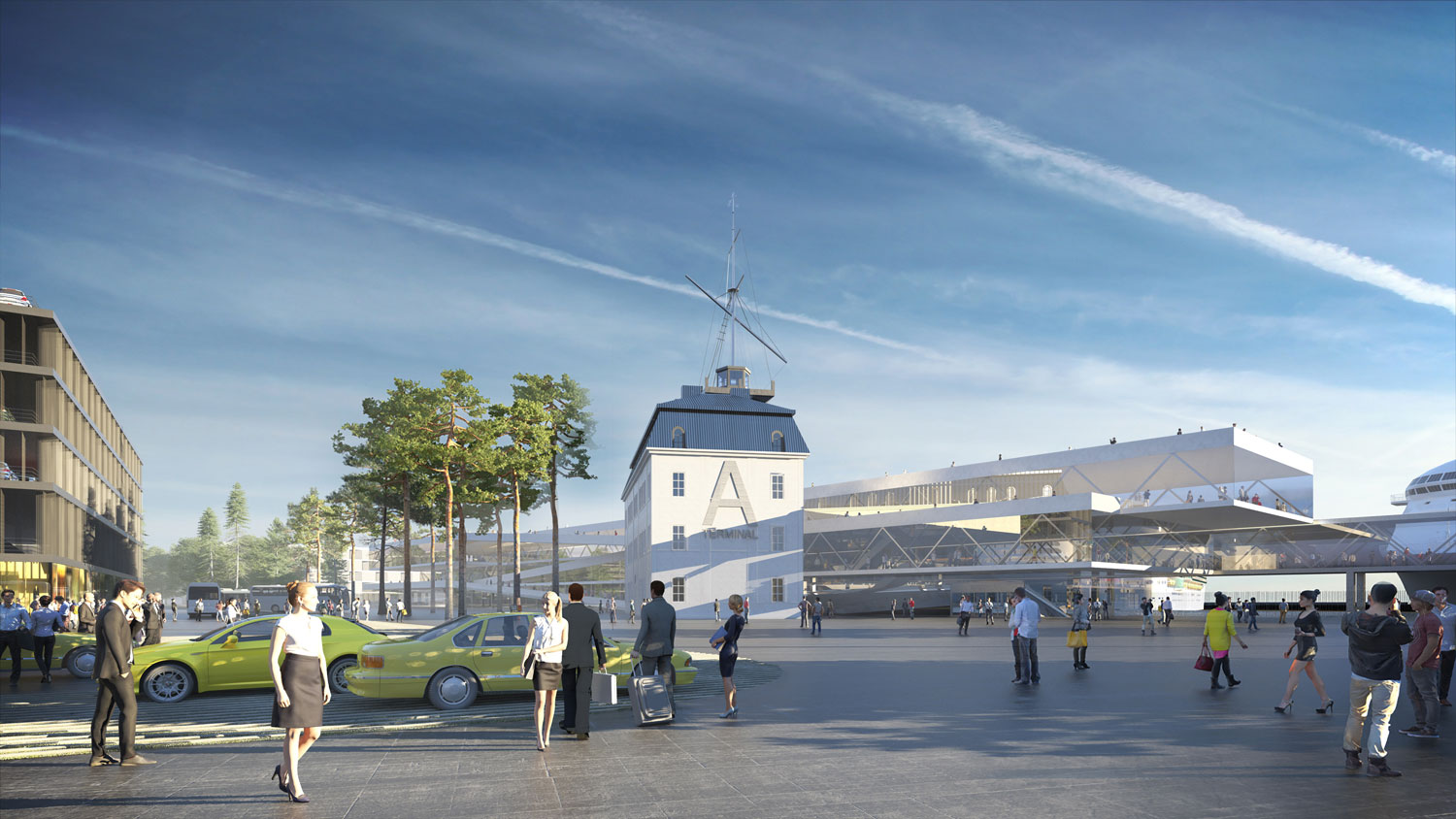
Rannavärav – Sadama street – Kaupmehe sild. Sadama street is an extension of first medieval pier (pre 17th c). Kaupmehe Sild at the end of Sadama street is the oldest part of todays port. Our proposal is to redevelop Sadama street together with bastion belt and reorganising terminal A to open up again view to the ships and port activities at the end of the street. This view would be visible all along Sadama street and would mentally connect Old Town and Port again.
Port authority building. Port Authority Building (end of 19th century) does not stand out any way currently. Our proposal is to restore the building in a sensitive way so that it stands again with main facade facing the sea. This would be the anchor point of the Sadama street.
Admiraliteedi Bassein. Former dock, started as a canal, current size 1899. Admiraliteet is the center of the all area and beyond.
20th c industrial heritage. 20th c industrial heritage. Unfortunately most of industrial heriatage is erased during last decades. Both sides of port pavement of huge concrete blocks (ca 3x6m) is remained and will be used to give raw and industrial character for seaside promenade. Only one crane is left at the port.
Püha Siimeoni Ja Hanna Kirik. Small wooden orthodox church for dock workers (1752) beautifully renovated, but in a very unfavorable urban context. Our proposal is to design small square around church.
Kochi aidad. A limestone storage buildings (1870) currently renovated as a shopping. Our proposal is to keep layout of streetscape there and use the same industrial atmosphere while designing spaces between Lootsi and Uus-Sadama streets.
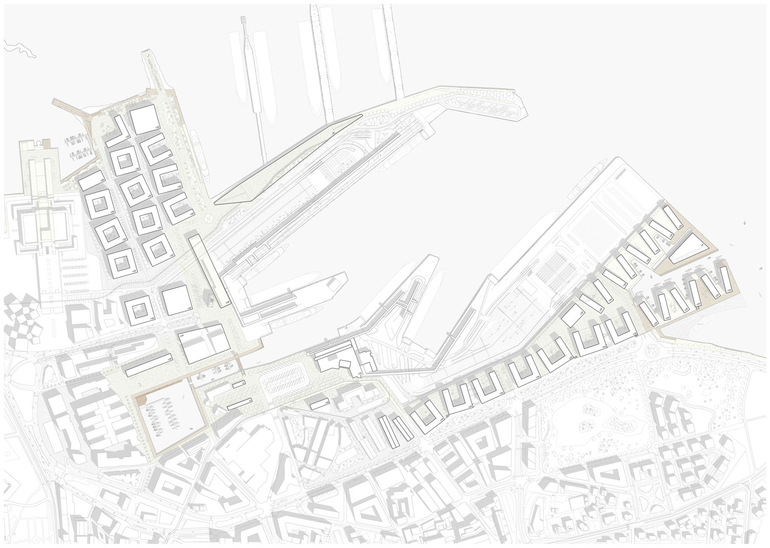
Masterplan with Tallinn’s dna
In Tallinn, there is already an ongoing process which is growing the city toward the harbor domain. Rather than removing the port activities, we believe that these activities should remain as much as possible in the city center and should become an important part of the experience of the future Tallinn. One of the main reasons for Tallinn’s character is precisely the exposure to the harbor activities, its rhythms and sounds. Even if these activities disrupt sometimes other urban functions, the identity of Tallinn is based on an operation that has to adjust to these rhythms and sounds. All in all, we believe that in order for the masterplan to build on the identity of Tallinn, we have to operate in multiple discreet operations which can be implemented independently overtime, without the necessity of a Grand Plan where the parts are absolutely determined from the beginning, but rather as a series of operations that can be incrementally deployed and adjusted to the economic and political cycles, and to incorporate a wide range of new urban technologies, such as gps logistics and self-driven vehicles, that are destined to transform cities in the near future. As a conclusion, our proposal therefore involves a series of actions:
– Consistency of the Waterfront Promenade
– New Insertions of Dense Urban Fabric along the Waterfront/Harbor
– Bringing the Waterfront into the City: Admiraliteedi Square
– A Network of Perpendicular Programmatic Threads
– Public Transport Enhancements and Logistics
– Preservation of Port Heritage
– Flexible Stages and Temporary Uses Before Main Solutions
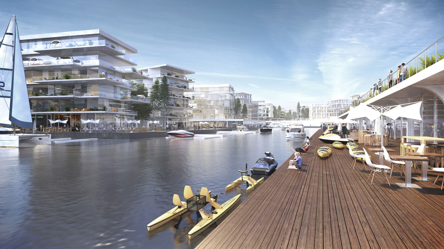
Consistency of the waterfront promenade
To give consistency to the system of public spaces along the waterfront continuous seaside promenade is proposed with minimum crossings with car traffic. Promenade will join together all different public activities along Port and will be one of the backbones of the area. Continuous seaside harbour promenade functions alternatively as an ISPS border, but it is also a spectacular journey around the port of Tallinn with diverse viewing platforms, elevated walkways and park stripe connecting all terminals and different quays by vehicular and pedestrian traffic. Port activities will be made visible through these walkways, as a part of the everyday experience of Tallinn. In order to be able to achieve spatial continuity of promenade, a number of actions are proposed:
Terminal System Reconfiguration. Passenger Terminals A/B and D: The Terminal’s urban park forms an important part of long-planned seaside promenade. Because vehicles’ access to berths have recently been moved away from the passenger terminals, the new more open and pedestrian friendly configurations are possible. Main two passenger terminals A/B and D will be reconfigured and compacted, but kept broadly in their current locations. When the terminal A will be demolished in future, it will open the view to the ships along ancient Sadama street. The original Port Authority Building will be fully exposed then. The whole area all around the compacted passenger terminals could be therefore open to the public.
Cruise Terminal. Seasonal cruise terminal will be also connected by the seaside promenade. The terminal will contain additional program. In mentally distant location, public function will help to open up that area. The Northern dock (Lääemuul) will be open to the public on its north side, leaving only the roll-on roll-off platforms as permanently secluded area. Meanwhile, the northern side of the dock will only be closed during the cruise season, in the summer, with a movable fence that will only be closed when cruise ship mooring takes place. This simple operation will multiply the potentials of the northern dock as a very valuable urban space, available for public enjoyment.
Vehicular Accessibility. Vehicle entrances have their own smaller terminals/ gates elsewhere – designed similarly as main terminals with some features commonly recognizable. Crossing of pedestrian/ passenger/ vehicle traffic is kept minimal due to several measures and devices. Main access/ exit for trucks in southern part is planned under the elevated promenade. Inside the closed areas sufficient buffer areas for vehicles is kept in front of the ISPS check-in gates. Limited size multi-functional parking houses (for car rent, some temporary parking etc) near by passenger terminals work as buffers before above ground parking can be reduced in future due to better public transport, light traffic solutions and adjacent private underground parking garages.
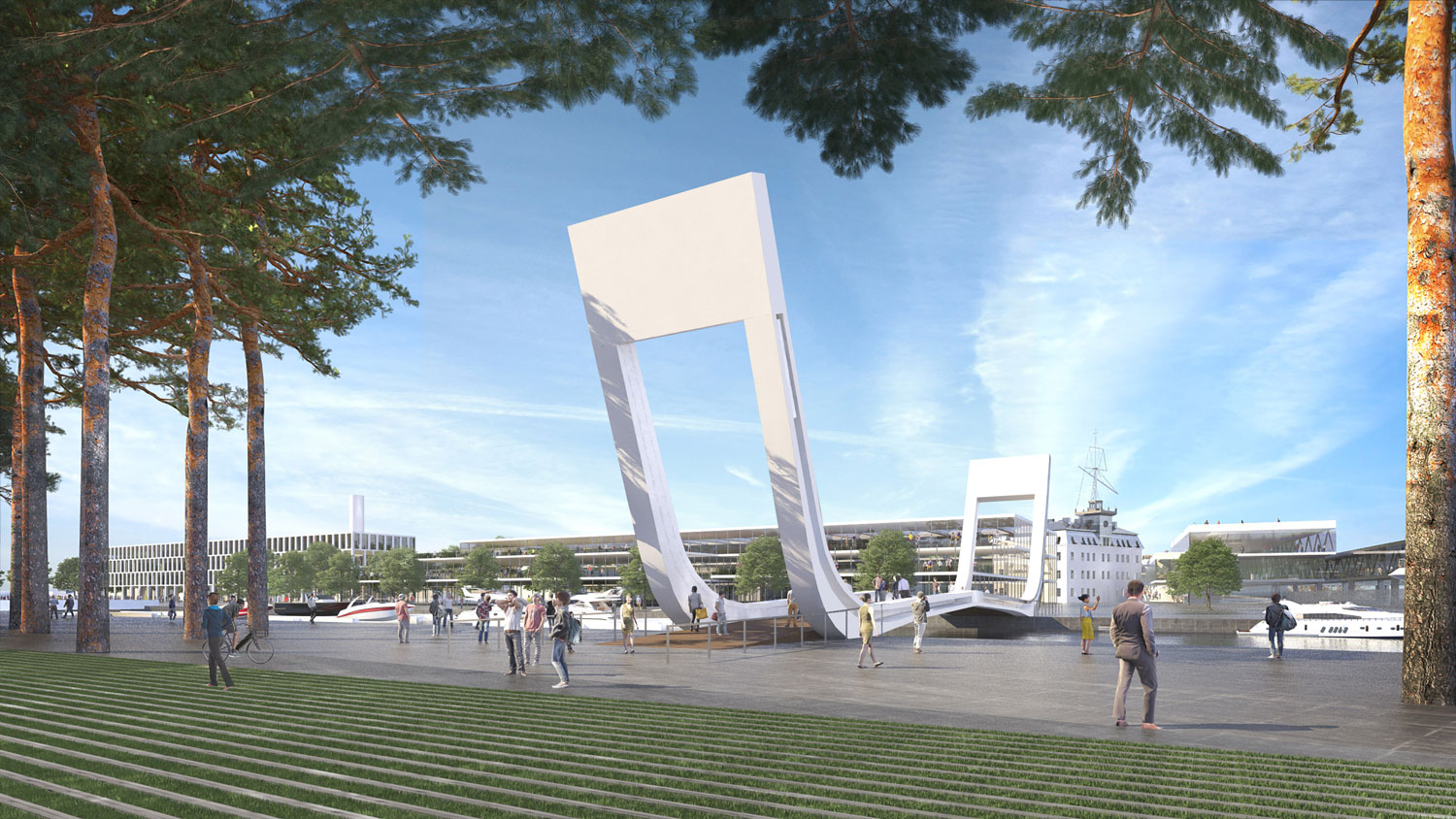
Admiralty Canal Crossing. In order to give continuity to the waterfront promenade between the North and the South docks, a crossing of the Admiralty Canal will be necessary, to shorten the path between the northern dock and the city. We propose to make this connection in the form of a lifting pedestrian bridge over the Admiralty Canal. If a vehicular connection is needed across the Admiralty Canal, it should happen underground, together with the provision of public parking facilities, so that the ground level is preserved for pedestrian use, which should be given priority over all the area that remains of exclusive port use.
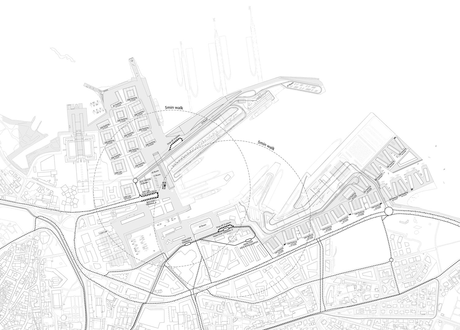
Public transport enhancements and logistics
Public transport is considered as a central and preferred type of transportation in whole city center area. New street network is planned with future perspectives for public transport. Existing city center and sea promenade should be connected with wide park-like streets, after every 300…400meters. New bus lines would follow those streets.
Tram. New tramline will serve for both terminals with single tramstop on southern quay near by the new pedestrian bridge. In future the tramline could be extended to the east, through public port areas to the Reidi street.
Walkways and light traffic. New pedestrian-friendly street network with other networks of public space (harbour promenade, plazas, squares and green lines) enhances immensely convenience for light traffic and other alternative transportation options.
Passanger terminals. Vehicles’ access to berths has moved away from the passenger terminals making room for pedestrian-friendly quays. The whole area all around the compacted passenger terminals will be open to pedestrians.
Roll-on-roll-off car access. Car entrances are combined with truck entrances to minimize pedestrian/ passenger/ vehicle traffic crossings and will be carefully designed. Car entrances could have their own smaller iconically recognizable “gates” similar to the main terminals. Main exit gate for trucks to Reidi St. is planned under the elevated promenade in the intersection at Pikksilma street. In this respect the port area is a special case – port activities, including ro-ro car traffic, is accepted and exposed, but should be regulated for balancing the city and the port. So, the creative solutions will be preferred and exposed here.
Occasional parking. Extensive underground parking is not preferred option when considering future perspectives – city of Tallinn has decided to reduce radically parking possibilities in the center for encouraging the use of other, more city-friendly, transport options. Huge carparks will be replaced efficient multifunctional on-ground parking houses (combined w retail or living). Later these higher ceiling garages can be converted into other uses.
Answering strategical dilemmas. Different strategical development scenarios should be considered and taken account. Port of Tallinn could function well in the city center and it is great importance for the city as well.
– Maintaining both Northern and Southern quays is essential for the port. Northern part is historical place of the port and is only possible location for cruise ships. Southern part has 60% of the traffic – so both parts are equally important.
– Car bridge over the Admiralty Channel should be avoided in any case.
Main scenario. One-level traffic with new street network, reduced parking, enhanced flows and other smart city solutions. Unstopping flows (to the port and away) should be enhanced. Stopped cars (parking) should be restricted and not favoured. For reducing an impact of port related roll-on roll-off car traffic (one ship could contain up to 2 km of cars) smart solutions should be applied (new traffic control methods, new generation software applications). As a result a concentration of cars is stabilized and reduced in peak hours. All waiting areas for trucks will move out to suburbian parking lots (electronic check-in, Smart-Port project etc). Small amount of truck-ready multifunctional buffer places will be kept for temporary emergency situations. Autonomous (driverless) cars (=autos), roll-on-roll-off biking, bike and other small vehicle rentals will reduce the amount of cars. Car rental and car sharing ensure better rotation of vehicles and reducing a needs for long time parking.
Tunnel scenario. The possible car tunnel corridor should be reserved for future if traffic jams and congestion worsens and cannot solved with any one-level planning tools and soft solutions. Arguments for the car tunnel in that case:
– Roll-on roll-off traffic means big amounts of cars and trucks. As long as Helsinki and Stockholm maintain heavy Ro-ro traffic in their center city terminals it is not possible to direct heavy traffic partially into Muuga.
– Tunnel will reduce traffic between Old Town and the harbour (also between Old Town and northern seaside).
– Building a new quay could be much more expensive than the 500m tunnel.
– Car bridge should be avoided in any case. Heavy traffic bridge is also higly expensive, but it would destroy all the expected quay-side citylife in the very center of both the port and the city.
– If extensive -10m deep parking garages are already built surrounding blocks then -12m deep tunnel is almost the same difficulty, but is much bigger importance.
– There are enough places for extensive ramps without interrupting the area. Ramps could be shared partially if more underground parking will be built in future.
– Reducing cars and traffic noise improves environment for city life.
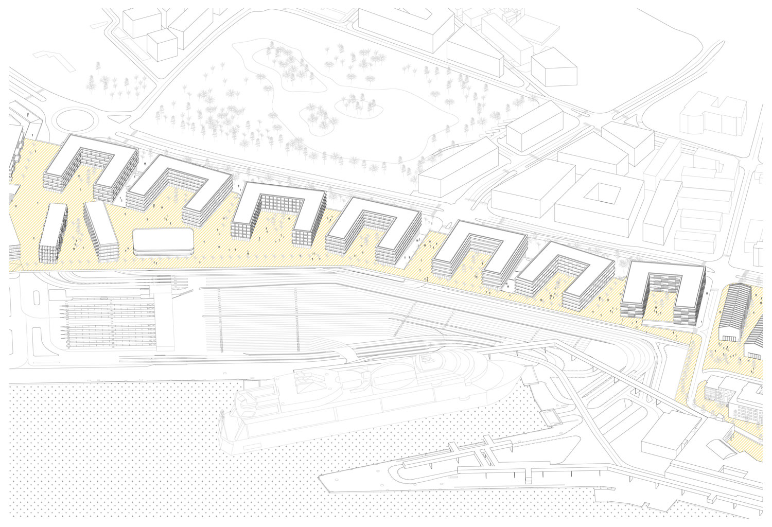
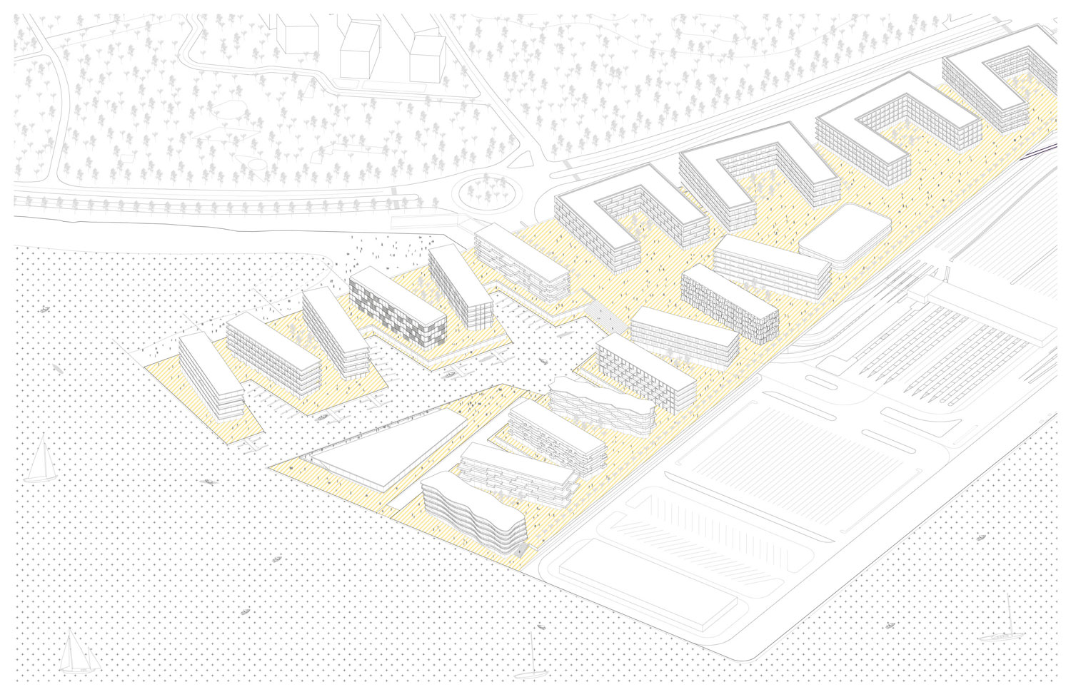
New insertions of dense urban fabric along the waterfront/ harbor
The insertions that we propose are:
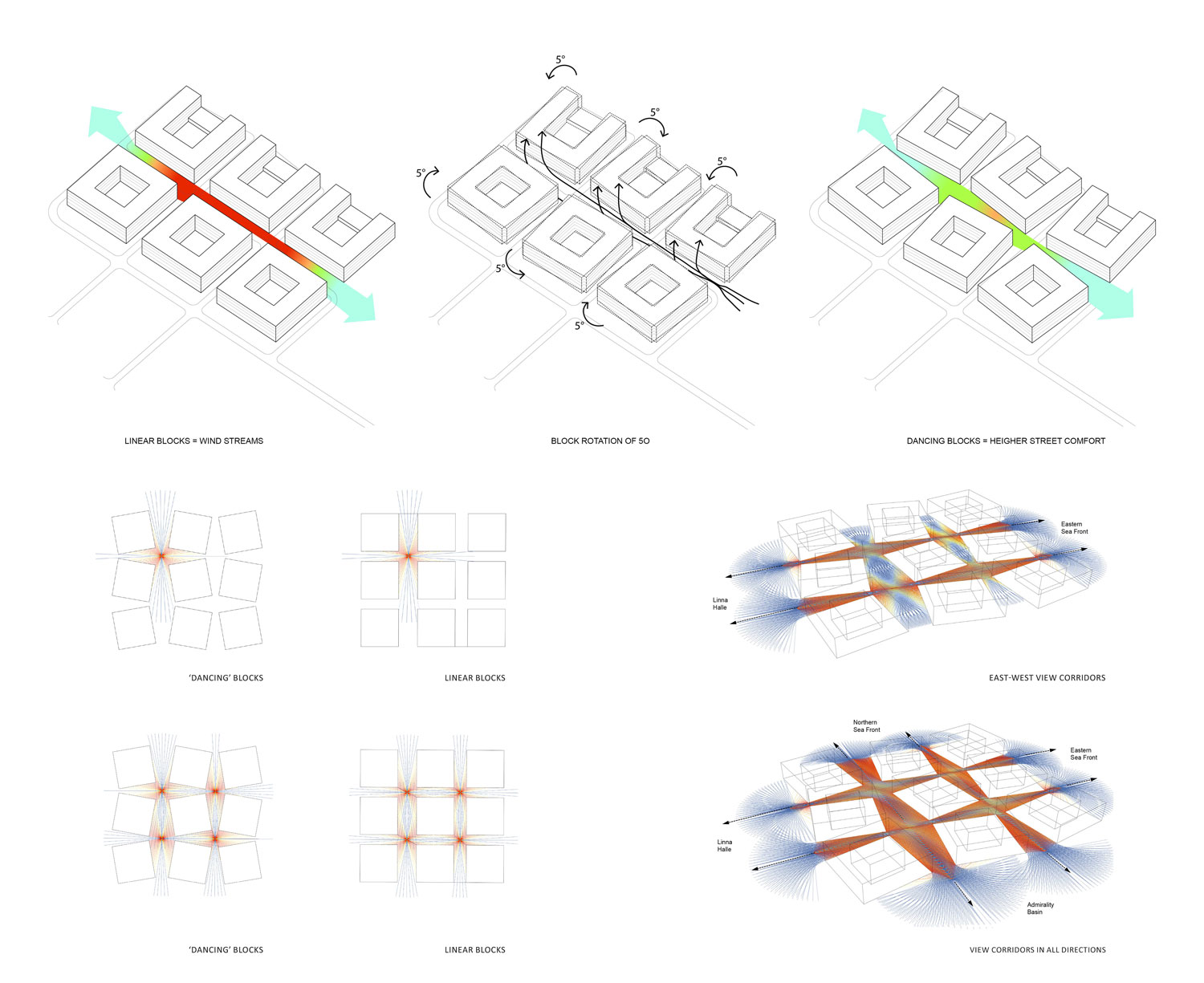
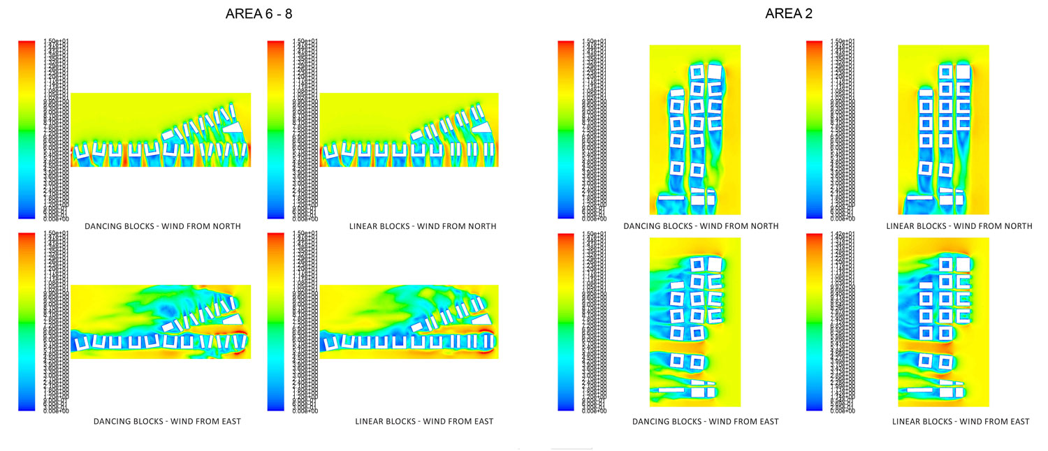
The village. To the East of the LinnaHall, we have proposed a relatively dense urban fabric, in the image of many fishing villages in old port cities, like Barcelona, San Sebastian, Melbourne, Amsterdam, Antwerp… where a network of relatively narrow streets with views to the sea create a microclimate which shields the streets from the winter winds, enabling an intense urban life in the lanes. Given the specificity of Tallinn’s climate and the necessity to ensure good solar exposure, we have limited the height of the buildings to 20m and imposed a height limit of 4 floors for 50% of the urban footprint in order to ensure the adequate penetration of light in the streets and the courtyards, and to provide an animated skyline for this part of the city, which will be visibly prominent from the sea. The grid is based on rectangular footprints which enable the occupation by a variety of functions: from mid-size retail to small scale, to modern office building footprints and residential blocks, we have ensured that the courtyards are at least 15x20m (one side partly opened towards street), and the depth of the bay is limited to 20m, so that we do not have spaces that cannot be reached by natural daylight and natural ventilation within that fabric.
Buffer city. Between the closed ro-ro port zones and the Eastward extension of the city-center we have located a band of urban fabric which is designed to articulate the edge between the urban fabric and the port platforms on the south side. The so-called “buffer city“ is aimed to resolve the border between the harbor terrains and the urban tissue on its border, and the enormous demand for parking structures: the line of urban blocks, approximately 70m x70m, is lifted from the ground 5,5m, producing a line of tall retail spaces along Reidi St while providing a substantial amount of parking platforms on ground level. On the north side of this array of blocks, we have placed a publicly accessible walkway (part of the continuous promenade) which overlooks the grounds of the harbor, enabling citizens to watch the port operation from above, while preserving the public space from the noise and visual blockage produced by the vehicles on the ground level. Every block will have an ample courtyard for the provision of community facilities for the buildings in every block. The transversal streets will be ramped, providing pedestrian access to the elevated walkway. Like the village, these blocks have been designed in order to provide proper daylighting and natural ventilation to all the building in the area, with a 15…20m width, which will allow indistinctively for residential or employment spaces.
East pier development. The fabric along Reidi St will be extended out of the waterfront with a pier aimed to host an important concentration of building density and a marina which will contain the remnants of shipwreck and a sports harbor. The East pier development will be developed into an area dedicated to urban sports, with the proximity to Kadriorg Park, and an urban sports complex located on the edge of the pier in order to place some destination/thematic program at the end of the buffer city development. Like in all other urban developments in this masterplan, the fabric is characterized by being totally flexible in terms of hosting either residential or employment space, and including a substantial amount of commercial and leisure facilities.
Bringing the waterfront into the city: admiraliteedi väljak
Admiraliteedi Square appears to be one of the crucial nodes in the structuring of the new harbor-related grounds. Admiraliteedi Square is likely to become one of the most most important civic spaces in Tallinn, a new urban center formed around the presence of water. Symbolically this should become an ideal representation of Talinn spirit. In our proposal Admirality basin is treatead as an urban square with clearly defined and active building front. The south facing side of Admiralty basin is one of the best spots on the area for the public realm. We propose the location of an importanat public or cultural program.
Exposing port activities to city and passanger terminals A/B and D. Because vehicles’ access to berths will be moved away from the passenger terminals, the new more open and pedestrian friendly configurations around terminals area possible. With simple moves – like opening up area all around terminals to pedestrians – port activities, ships and sea will be exposed to the city. In our proposal we open again Sadama and Uus-Sadama streets with view to ships. In this way the current image of the port as a dead end in a cityscape is reversed. Main two passenger terminals A/B and D will be reconfigured and compacted, but kept broadly in their current locations. We propose that A/B and D terminal have shared drop off area, which is organised around one central park-like square with new tram stop and ample area for bus stops and short-term parking.
New pedestrian bridge. We propose to make connection between North and South docks in the form of a lifting pedestrian bridge over the Admiralty Canal. If a vehicular connection is needed across the Admiralty Canal, it should happen underground, together with the provision of public parking facilities, so that the ground level is preserved for pedestrian use, which should be given priority over all the area that remains of exclusive prot use.
Temporary uses before main solutions. Before and parallel to more long-term planning, designing and construction processes so-called beta-versions of new cityscape can offer diverse possibilities for testing main solutions by temorary and easy-to-implement interventions and structures. Thus better working variations could be selected out or new perspectives and solutions discovered. Wider public gets used to visit and walk through the areas. Several optional interventions could be done right now:
– Beta-bridge over the channels neck
– Branch of the harbour promenade – a shortcut through the closed port areas („public gangway“) could be created as a temporary beta-version of port-city.
– Exposing and regenerating new port related heritage (by temporary conversions and events).